Since 2021, photographer and historical researcher Estelle Slegers Helsen has been wandering around Lochaber in the footsteps of the Scottish photographer W.S. Thomson MBE (1906-1967). She takes photographic remakes roughly 70 years after Thomson initially captured the landscape and talks to local people along her journey. Every fortnight, Estelle takes our readers to various places in Lochaber. This week, she focuses on Rannoch Moor.
Rannoch Moor has a mythical status.
The boggy moorland, an expanse of around 50 square miles, stretches from Loch Rannoch in the east to the entrance to Glen Coe in the west.
It is ‘The one perfect specimen of a Highland moor’, mountaineer W.H. Murray wrote in a survey commissioned by The National Trust for Scotland in 1960, which
was published two years later as a book entitled Highland Landscape.
Each time I drive across it or take a train on the West Highland Line between Glasgow and Fort William, the vast, flat, desolate area looks and feels completely different because of the ever-changing weather conditions and the always changing light.
And sometimes you just see nothing because of heavy mist or the pitch dark.
In the late 1940s, Thomson published the first edition of Let’s See Glen Coe and Loch Leven, featuring black-and-white photographs taken between 1945 and 1947.
Andrew Paton provided the accompanying text for this booklet.
With regard to Rannoch Moor he wrote: ‘The world here is very spacious. And it is a
world that is seen best from a coach or a car. Here is scenery unique in Britain. A
vast stretch of wasteland, unproductive, untenanted, boggy, brackish. On a day of
clear air and sunlight and showers the beauty is breathtaking.’
One of Thomson’s photographs in the booklet is entitled A Typical Study of the Moor of Rannoch.
The foreground stretches to the hills in the background topped with massive white clouds. I believe that this photograph lacks one essential component: water.
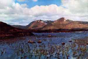
A photograph that comprises all the Rannoch elements is a view of Lochan na h-Achlaise towards Black Mount, with cotton grass in the foreground, water in the middle and mountains and clouds in the distance. As this is also a monochrome shot, you have to imagine the colours yourself.
A similar colour photograph was printed in several editions of Let’s See the West
Highlands, published in the early 1950s.
The water invokes a hundred shades of blue. Brown and gold-coloured grasses overlay the black peat of the moor.
This site is the most unchanged of all the remakes I have produced so far for the Lochaber series.
It is astonishing how the snow patches on the Clachet traverse and Meall a’Bhùiridh are intact. And the rocks in the lochan are still perfectly in place. Mother Nature has added birch trees on an island in the middle of the frame.
At the back, just in front of the mountains, runs the West Highland Way, established in 1980, touching the western edge of Rannoch Moor.
It is the wildest and most remote section of the 96-mile-long popular hiking way from Milngavie to Fort William.
On a good day this area offers an unforgettable walking experience. Although, this section can be very adventurous if the weather isn’t favourable.
It is harder, even for experienced hill walkers and mountaineers, to walk across Rannoch Moor in an east-west direction.
As I write this article, I am searching for photographs of W.S. Thomson, published
in climbing and hill walking books on Scotland from the 1930s to the end of the
1960s.
One of the selected book collections is that of the Scottish Mountaineering Club, safely held in the Andersonian Library of the University of Strathclyde in Glasgow.
In the SMC Guide The Central Highlands, published in 1934, I read: ‘A track runs
across the moor from Rannoch Station westwards to Kingshouse Inn (now Kingshouse Hotel), about 13 miles.
‘At first, the path skirts the shores of Loch Laidon and is fairly good, but when it turns west near Tigh na Cruaiche and contours across the higher ground above the 1150-foot level it practically disappears.
At the Black Corries Lodge, however, a driving road is reached, and four miles along this brings one to Kingshouse Inn. (Rannoch) Moor with its encircling and picturesque peaks, makes it quite unique from the scenic point of view.’
Even 90 years later, there is still no way to cross except on foot. Fortunately…
- Travel in Time – Lochaber Series was supported by the West Highland
Museum and the Year of Stories 2022 Community Fund. Estelle has published a
64-page book with 30 side-by-side then-and-now pictures, which you can find
in local shops or buy online – www.travelintime.uk